Pages

New Zealand - Aotearoa by BlossomFlowerGirl

New Zealand Time

Aotearoa Snapshots

Click on Flag or Select Your Language to Translate

ArabicChinese (Simplified)DutchEnglishFrenchGermanHindiIndonesianItalianJapanesePortugueseRussianSpanishTurkishUrduBengaliNepali

Tēnā koutou katoa

This is all about New Zealand - Aotearoa - and the time I spent there. Magical times, beautiful scenery, gushing geysers, thermal wonderlands. Hear about Waitangi Day, discover the meaning of the word "Aotearoa", see the Glaciers, read about hangis and Hakas, and visit the beautiful Bay of Islands. So come with me on a journey - a journey to The Land of The Long White Cloud.
Kia ora


CHRISTCHURCH EARTHQUAKE TRIBUTE 2011


Watch The Haka

16. Bay of Islands - Waitangi

Thursday 4 January

History of Waitangi Treaty Grounds

The Waitangi National Trust estate comprises 506 hectares and includes the site where the Treaty of Waitangi was first signed on the 6th of February 1840. The public have access to this important historic site because it was purchased by Lord and Lady Bledisloe in 1932, and gifted to the people of New Zealand in trust. Lord Bledisloe was Governor-General of New Zealand at the time, and he and Lady Bledisloe visited the property at the suggestion of a local lawyer and MP, Vernon Reed. (Reed had been unable to convince successive governments to purchase the land when it came up for sale).

After only five years in New Zealand and one visit to Waitangi, the Bledisloes recognised the importance of Waitangi as the birthplace of New Zealand as a nation. In November 1932, a Deed of Trust set out the objectives for a place of historic interest, recreation, enjoyment, and benefit for the people of New Zealand, and for the governance of it. Priority was given to the repair and restoration of the former home of the first British Resident to New Zealand, James Busby and his wife Agnes. Initially called the "Residency" the house was renamed, at the request of Lord Bledisloe, to the Treaty House.

Ngātokimatawhaorua.

This mighty waka (canoe) was built by the Ngā Puhi people for the 1940 centenary of the signing of the Treaty of Waitangi, and sits on the grounds at Waitangi and is believed to be the largest waka ever built.

Named Ngātokimatawhaorua., the canoe requires a minimum of 76 paddlers and can carry 55 passengers and was launched as part of the Centenary Celebrations in 1940, to mark 100 years since the signing of the Treaty of Waitangi.

Ngātokimatawhaorua Figurehead


It bears the name of the canoe of the great Polynesian explorer Kupe, who visited Aotearoa (New Zealand) many hundreds of years ago. It was carved from the trunks of three large kauri felled in the Puketi Forest, and its design is based on that of earlier waka used by Māori to travel up and down the coast of New Zealand.

It was named after the canoe which brought the Māori people from Hawaiki and was captained by Nukutawhiti, the grandson of Kupe, the Polynesian discoverer of New Zealand. Ngātokimatawhaorua is launched every year on the 6th February, to mark the signing of the Treaty of Waitangi. At 35.7 metres long and up to 2 metres wide, it weighs 12 tonnes, and is a key attraction at the Waitangi Treaty Grounds in the Bay of Islands.

15. Bay of Islands - Waitangi

Thursday 4 January

The Marae - meeting place

The Marae, sacred open meeting area, generally situated in front of the "whare runanga", communal meeting house, is the area of greatest mana, the place of greatest spirituality ; the place that heightens people's dignity, and the place in which Māori customs are given ultimate expression.

The Marae is the turanga-waewae of the Māori. It is the basis of traditional Māori community life. It is their home. In the Marae official functions take place - celebrations, weddings, christenings, tribal reunions, funerals.


Te Whare Runanga Marae


Te Whare Runanga is the meeting house (marae) at Waitangi, and was built to commemorate the Treaty Centenary Celebrations in 1940. It symbolises Māori involvement in the signing of the Treaty of Waitangi, and its underlying role as the document which brings the people of New Zealand together as one nation and was designed to stand alongside the Treaty House.

Although similar in apperance to other marae around New Zealand, Te Whare Runanga is unique because it was built as a national marae to be shared by all Māori tribes.

As you enter Te Whare Runanga, you will notice a figure at the apex of the gable - this is Kupe, the Pacific explorer. The carvings depict ancestors from many Māori tribes.

Kupe

Kupe sits at the apex, and according to Māori legend he was a great chief of Hawaiki and discovered Aotearoa - Land of the Long White Cloud.

The story of Kupe and the meaning of Aotearoa

Kupe left Hawaiki in his waka the Matawhaorua and travelled in search of the fish of his ancestor, Te-Ika-a-Mäui. He had chased Te Wheke Muturangi (a great octopus) during this search.

While approaching what Kupe believed to be Te-Ika-a-Mäui, the wife of Kupe, Hine Te Aparangi, saw the Southern Alps from a distance and thought they were a cloud and called out, "He ao! He ao!" (A cloud! A cloud!"). As they drew closer she exclaimed "He aotea, he aotearoa!" (A white cloud, a long white cloud!). And so the land was called Aotearoa - 'Land of the long white cloud'.

Kupe confronted and defeated Te Wheke at the entrance to Totaranui (Queen Charlotte Sound) and he travelled around Aotearoa naming many places along the way. After circumnavigating the North and South Islands of Aotearoa, Kupe and his crew returned to Hawaiki with treasures such as preserved moa flesh and pounamu (greenstone).


Entrance


Te Paepae Tapu


This is the threshold, the door sill (of a meeting house door).

Inside Te Whare Runanga
The lighting is fairly subdued so some photos were very dim and have not been included. Tribal art styles are represented in the kowhaiwhai (painted rafter patterns), tukutuku (reed panels) and carvings.


Hand carved totara

The Māori of the South Island contributed this handsome carved totara "Coronation" Chair and a beautiful block of tangi-wai greenstone to rest beneath it.

Wharenui


Inside Te Whare Runanga of Waitangi, the wharenui is the archive of their tribe (iwi) recording priceless history (hitori) through the art of carving, tukutuku panels,and kowhaiwhai (scroll work on rafters).

If you click and enlarge this photo, you can see the detail of the tukutuku and kowhaiwhai.

14. Bay of Islands - Waitangi

Thursday 4 January

Catching the 3pm ferry from Russell, I went to Waitangi and visited the Waitangi Treaty Grounds. Here is where the Treaty of Waitangi was signed and it is here you will learn of Māori history and culture.


The Treaty of Waitangi
The Treaty of Waitangi (Māori: Te Tiriti o Waitangi) was signed on 6 February 1840 by representatives of the British Crown and a number of Māori chiefs from the North Island and established a British governor in New Zealand, recognised Māori ownership of their lands and other properties, and gave Māori the rights of British subjects.The English and Māori language versions of the Treaty differ in translation and is therefore difficult to know, and agree, on exactly what was agreed.

Māori began to draw attention to breaches of the Treaty from around the 1960's onwards and subsequent histories have emphasised problems with its translation.

In 1975 the Waitangi Tribunal was established as a permanent commission of inquiry tasked with researching breaches of the Treaty by the Crown or its agents, and suggesting means of redress.

You can read the Treaty here in English and read here in Māori


Waitangi Treaty House - front

The Treaty House was the residence of James Busby and it was here in a marquee that the Treaty of Waitangi (Māori: Te Tiriti o Waitangi) was signed.


Treaty House Flowers


In the back garden were a number of brightly coloured flower arrangements.


Waitangi Treaty House - rear


The Treaty of Waitangi

This timber plaque can be found in the Te Whare Runanga Marae.

Click on the markers below to see images. You can also enlarge the map.

View Waitangi New Zealand in a larger map

13. Bay of Islands - Russell

Thursday 4 January


Russell of long ago

Russell was originally called Kororareka and was the first permanent European settlement and sea port in New Zealand. The Bay of Islands offered a safe anchorage and had a high Māori population who traded with the Europeans. Without laws, it became known as the "Hell Hole of the Pacific"


Hono Heke, Māori chief - New Zealand (1807-1850)


In 1840 the British government introduced the Treaty of Waitangi and Hone Heke was one of the first chiefs to sign it with the Māori people. But when the commercial operations of settlers began to threaten Maori trade and land ownership, Heke led several battles against the British, famously chopping down their flagpoles at Russell, North Island. (Good for him!).
He never lost a battle and neither side was able to claim absolute victory. Heke escaped penalty as his adversaries did not want to provoke tension in the region.


Many New Zealanders, Māori and non-Māori alike, see him as a political champion of his people.


Russell today
The Russell of today is a far cry from over 100 years ago. Now, it is a relaxed holiday get-away where people go to "get away from it all." Much less touristy and smaller than Paihia, Russell has a charm all of its own. Nothing much happens here and you can stroll along The Strand blissfully breathing in the fresh sea air with a beautiful vista before your eyes.

The Gables


Built in 1847, this lovely cafe/restaurant offers free coffees after 2.30PM. I sat outside just across the road looking out to the bay sipping a Cappuccino under the shade of a leafy tree.


Front Garden


This garden caught my eye as I walked past - with its colourful "chickens" and ornaments it was a real talking point. It also held fascinated children at bay too!


Te Whare Karakia o Kororareka

Christ Church, Russell / Te Whare Karakia o Kororareka was built in 1836 and is New Zealand’s oldest existing church and possibly the oldest building still used for its original purpose.

Its beginnings go back to the earliest years of Maori European contact in the Bay of Islands when missionaries from across the harbour at the Paihia mission station rowed across to take services in private homes.

Two Cultures
On a fifth Sunday the service is taken by clergy from the Waimate Taumarere Pastorate, the Māori strand of the Anglican church in NZ.

Much of the service is in Te Reo Māori but the NZ Prayer Book has an English translation on the opposite page, so all can follow it.

At other times Māori content is part of a special service including the Lord’s Prayer or a himene (hymn).

The Lord's Prayer:
E to matou Matua i te rangi
Kia tapu tou Ingoa.
Kia tae mai tou rangatiratanga.
Kia meatia tau e pai ai
ki runga ki te whenua,
kia rite ano ki to te rangi. Homai ki a matou aianei
he taro ma matou mo tenei ra.
Murua o matou hara,
Me matou hoki e muru nei
i o te hunga e hara ana ki a matou
Aua hoki matou e kawea kia whakawaia;
Engari whakaorangia matou i te kino:
Nou hoki te rangatiratanga,
te kaha, me te kororia,
Ake ake ake. Amine


Click on the blue markers to see photos. You can also enlarge the map.

View Russell NZ in a larger map

12. Bay of Islands - Russell

Thursday 4 January

Bay of Islands


Taken from the upstairs verandah of Pompallier House. See the people sitting in the garden relaxing? They were playing a game of croquet earlier and it was quite a rare thing to see.

Seacraft in the Bay of Islands

A close-up from the verandah.

11. Bay of Islands Russell - Pompallier House

Thursday 4 January

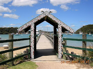
Coming back from the Hole in the Rock cruise, for an extra $4 you can get dropped off at Russell and then get the Russell ferry, the Bay Belle, which runs every 20 minutes back to Paihia, and this is what I did.


Pompallier House


In 1839 French Catholic Bishop Jean Baptiste François Pompallier established a mission at Kororāreka, where a two-storied building, housing a printery, tannery and storehouse, was constructed. When priests of the mission moved on, the building was used as a tannery and, from the 1870s, as a grand private home.

Bought by the government as an historic place in 1943, Pompallier House was for many years presented as a stately residence, with gracious verandahs and gardens.

Pompallier House rear garden and a detailed history


This French factory was built in pioneer New Zealand to print Maori language books for the Roman Catholic Mission. The last remaining building of a once-crowded mission headquarters, it is New Zealand's oldest Catholic building, and the oldest industrial building.

In 1838 three Frenchmen, a bishop, a priest and a brother of the recently-formed Society of Mary landed at the Hokianga. The arrival of a French Catholic Mission in New Zealand outraged the English Church Missionary Society and Wesleyan missionaries, who despised Catholicism and thought Maori should be Protestant. It also disturbed the British Resident at Waitangi, James Busby, who feared colonisation by France. But despite their hostility Bishop Jean-Baptiste François Pompallier's mission survived.

Reinforced by the arrival of more French Marist recruits, the Bishop moved to the Bay of Islands in 1839 to found the headquarters of his Vicariate of Western Oceania at Kororareka (now Russell). Kororareka, just across the water from the Protestant Church Missionary station at Paihia and James Busby's Residence at Waitangi, was by now the major trading port of the South Seas. New French Catholic recruits and supplies arrived here from France and were despatched around New Zealand and the Western Pacific. From here Bishop Pompallier and his confreres attended Treaty negotiations at Waitangi in February 1840. And they were here when war broke out on the neighbouring hillside five years later.

Our Lady of Mount Carmel


The narrow site and single, simple building that the Bishop purchased here soon became crowded with a chapel, cookhouse, well house, workshop, houses for Maori visitors and boatmen, and other outhouses. But the Marists knew that to spread Catholicism and to counter the "heresy" of their Protestant rivals they must produce religious texts in Maori. Spurred by the arrival of a printer and printing tools and equipment, they built a printery in 1841-42.

Short of funds, they resorted to the construction traditional to their native Lyon and Rhone Valley in the south of France. The lower storey is made of pise de terre, or rammed earth. The upper storey in pan de bois, or earth panels in a timber frame. The resulting impressive and elegant two-storey French colonial building, completed in 1842, has been a key feature of the town ever since.

In October 1842 the first Maori translations were ready and the printery, complete with bookbindery and tannery, began production. Its crowning achievement was 6,000 handmade copies of the 648-page Ko te Ako me te Karakia o Te Hahi Katorika Romana (The Teachings and Prayers of the Roman Catholic Church).

Religious Artefacts


By 1850, disagreement between Bishop Pompallier and the Marist Society, together with the demands of the growing colony, had led to their moving to Auckland and Wellington respectively. In 1856 the Kororareka mission property was sold to James Callaghan, who tanned leather in the printery until 1863, then moved into it with his family. By 1879, when the Greenways acquired the property, the building was derelict. But Hamlyn Greenway transformed it into an elegant home while his sister, Jane Mair, created a garden from the once-crowded mission compound and the neighbouring property, which Hamlyn also acquired. Then in 1904 the Stephenson family moved in and further developed both house and garden.

All of the families altered the building to suit themselves, but in doing so weakened it. This problem was compounded in 1943 when the Government transformed the house into a historic monument, "Pompallier House". The New Zealand Historic Places Trust took responsibility for the building in 1967. Realising that its history had been misunderstood (it had never been a bishop's palace) and that it had been structurally degraded, in 1990-93 the situation was resolved by returning the building to its original form in a restoration project that was a milestone for New Zealand heritage conservation.

The printery including the original printing press, bookbindery and tanning pits are again working to produce reproductions of the Roman Catholic prayer and instruction books that were printed here in the Maori language through the 1840s. The printery is the only building to survive of the crowded mission site.

The site of the first Roman Catholic chapel is marked in the beautiful garden that was created around 1880 long after the mission was disestablished. The garden is restored to its full glory as the Victorian/Edwardian garden of the later lay owners of Pompallier.

9. Bay of Islands - Paihia Esplanade Walk

Wednesday 3 January

Paihia is known as the Jewel of the Bay of Islands. The tree is the Pohutukawa Tree, also called the New Zealand Christmas Tree, and is one of the most outstanding plants of the entire New Zealand flora. With beautiful bright crimson flowers it is tough and hardy and can be seen in profusion along the coastal areas.

The Jewel in the Crown


Paihia Visitor Information Centre


This beautiful old building houses the Visitor Information Centre and other retail shops and is located at the Wharf in Marsden Road. The helpful staff will help organise and book activities, transport and cruises. Set amid beautiful clear waters it's a real delight just to stroll down and around this lovely area.


Ducks Crossing


One of the signs I spotted on my walk - alas I became "delete" happy and lost a few photos. (Sigh)

Paihia Hibiscus


Nodding in the breeze was this hibiscus along the waterfront.

10. Bay of Islands - Hole in the Rock Cruise

Thursday 4 January

Today I'm doing the Hole in the Rock cruise which departs from the Wharf at Paihia. There are two cruises daily - morning and afternoon. I chose the morning one which leaves at 9.00AM and gets back at 1.00PM as that would leave the rest of the afternoon free.

Motukokako Islands


The luxury catamaran the Tiger V, passes by the township of Russell (Kororareka) and several of the historic and culturally significant islands in the Bay, before heading out into the open sea.

Cape Brett Lighthouse


The 14-metre high Cape Brett Lighthouse stands at the entrance to the Bay of Islands and was built in 1908. An isolated settlement was established at Cape Brett in that year and included three identical houses for the lighthouse keepers and their families. Their duties included sending daily weather reports to the Meteorological Office.

For 70 years the lighthouse was staffed. In 1978, a smaller automated light was installed and with this automation came the end of the settlement.

We cruised past the Cape Brett Lighthouse, before arriving at the stunning Motukokako Island, home of the majestic Hole in the Rock.

Motukokako Island (Hole in the Rock)


At the outermost limits of the Bay of Islands, Motukokako Island, also known as Piercy Island, features a large geological fault that has created a sea arch large enough for tour boats to pass through when the weather is good enough.

Piercy Island was named by Captain James Cook, who also named the nearby peninsula Cape Brett, both after Rear Admiral Sir Piercy Brett, then a Lord of the Admiralty. It is called Motukokako in Māori.

The 210 foot hole at sea level was created over centuries by wind and waves making it one of the most naturally beautiful sites in New Zealand.
Today the island is of geological interest because of certain exposed rocks, as well as being a tourist attraction.


Going through the "Hole"


As we neared the dramatic Hole in the Rock our Skipper said over the loudspeaker the weather was too rough and the new boat we were on was too big to fit through and we wouldn't be able to go through the hole. I was so disappointed and so, I know, were the other passengers. The Skipper tried a second time to go through but with the same result and said he was sorry but he'd have to turn around and give it a miss. The disappointment was palpable.

Then he said he was only joking and we would be going through - seems this Cap'n has a good sense of humour and likes to have his little joke - it certainly caused a lot of fun and we appreciated even more the awesomeness of going under that majestic hole.

As we ventured into the dramatic Hole in the Rock – we held our breath in anticipation as the skipper navigated through the narrow space and admired the rock walls which soared above us. If you're on the top deck watch out for water drops!


On the Tiger V


Otehei Bay on Urupukapuka Island


Urupukapuka is the largest island in the Bay of Islands and is historically important with a rich archaeological landscape. A total of 66 archaeological sites have already been identified on the 208ha island. Most date from hundreds of years of Maori settlement prior to European arrival.

Today it is a recreational reserve. The Zane Grey Café does very good lunches - I had fish'n'chips and a glass of wine. It is a lovely relxaing place to unwind on the golden beach - the water was so clean and so clear, and you can also camp there.

Did you know that the Zane Grey Café/Resort was opnce home to the famous American adventurer and writer Zane Grey?

Urupukapuka Island is the largest of over 140 islands in the Bay, and is steeped in both Māori and European history. Urupukapuka has an area of 580 acres and was vested by the Crown as a recreational reserve in 1970. And as such, Urupukapuka is the only island in the Bay readily accessible to the public.

Fullers Ferries


Mapping Route


The last two photos aren't mine, they're from Fullers as I didn't think to photograph the boat and I lost my copy of the map route.

8. Bay of Islands - Paihia Accommodation

Wednesday 3 January

The YHA Paihia is a lovely two-storey white weatherboard place on the Cnr of Kings & MacMurray Roads, and a mere 100 meteres from the beach. The outdoor area is undercover with some nice greenery with the lounge overlooking it.

Paihia YHA


Outdoor Courtyard


Most people staying here ate outside, there is a thick clear plastic "curtain" to protect from the wind.

Juniperus chinensis 'Pyramidalis'


The potted plants placed around the area made a nice touch and gave it a pleasant ambience.

The Lounge Room


Comfortable sofas and colours of green and burgundy made for a welcoming feel.

Lounge and Computer Area


The area immediately to your right as you enter has computers and internet.

The Dorm


This was my dorm - a 4 bed dorm, mine was on the left and each dorm has its own small ensuite. The YHA also has single/double/private rooms.

7. Bay of Islands - Te Ti Bay, Paihia

Wednesday 3 January


Beautiful Te Ti Bay


The broad sweep of Te Ti Bay is Paihia’s most popular recreation beach and a variety of activities are here. It is fantastic for picnics, swimming, sunbathing, surfing, water skiing, fishing, kite surfing or wind surfing.

At the northern end of the beach you will pass Te Ti Marae on left. It was to this marae that Maori chiefs retired for the night to consider the Treaty of Waitangi before deciding to sign it at Waitangi on 6 February 1840.

Paihia’s main boat launching ramp is on your left at the northern end of the bridge. In summer it is a bustling scene from before dawn as fishing enthusiasts launch their craft.


Paihia Click on blue marker for photo

View My Saved Places in a larger map

Click on the blue marker for a photo. You can also enlarge the map.

6. Bay of Islands - Haruru Falls & The Magic Bus

Wednesday 3 January

The Magic Bus


Well, it's back on the bus as we travel coast to coast. We have left Opononi behind and head east on the SH 12 (State Highway) going through Motutoa and Kaikohe passing some beautiful countryside. When we reach Pakaraka, we make a left turn onto SH 10 and turn right at Puketona on Puketona Road for our next stop.

Haruru Falls


Haruru Falls was New Zealand's first river port and an aramoana (sea road or ocean path) for the inland Maori tribes and for the early vision boats. Surrounded by wilderness, the water of Haruru Falls in Paihia on the North Island of New Zealand cascades over the rock cliffs to the pool below.

Haruru Falls provides a break from the coastal scenery of the Bay of Islands area. This 5m waterfall spans the Waitangi River so it's much wider than it is tall and you can kayak to the waterfall from the Waitangi Estuary. It's just a short drive from the seaside town of Paihia and a just-as-short walk to the falls - 3 kms.


Haruru Falls


Below:Click on the blue marker to see a photo.

View Haruru Falls, Paihia NZ in a larger map

5. Bay of Islands - Opo the Gay Dolphin

Wednesday 3 January

Opononi at Hokianga Harbour was our next stop, and here in the small visitor's information centre, we heard the tale of Opo the gay dolphin and watched a black and white video from 1955. I have searched Youtube but have been unsuccessful in finding it, so I will tell you the story.

Edited: Please note, the video is finally available on youtube. I have uploaded and added it to this post. You will find it near the end of this post after the story of Opo. I hope you enjoy the film as much as I did when I saw it.


The Story of Opo
In the early summer of 1955, a lone bottle-nose dolphin swam into the Hokianga Harbour and started reacting with humans. Known as Opo, she became a favourite, first of the local community, then of its holiday-making visitors, and finally of the whole nation.

She reacted well with most everyone she came in contact, and especially with thirteen-year old Jill Baker, whose parents ran the nearby tearooms. Opo and the girl formed a very strong bond; Opo would tow Jill around the bay, and the girl would teach her tricks. Opo was especially careful and gentle when she was around small children. She loved children but seemed to know how fragile they were.


Very few local Maori played with Opo. They believed Opo was a taniwha, a messenger sent by Kupe back to his point of departure for Hawaiki. Dolphins have also figured in Western mythology, from the time of the Greek gods, as creatures friendly to humans. So in Opononi, Polynesian and European mythology came together to form a fabric that was a uniquely New Zealand one.

Above: Opo

Once the first newspaper articles and photos appeared in December 1955, Opononi became a magnet for holidaymakers wanting to see her. Hordes travelled by car or bus along dusty, unsealed roads to stay in the camping ground or the hotel, both of which quickly became booked out.


As thousands of visitors started to arrive at Opononi, she put on a show for them at the beach there almost every day, making some people scared for her safety: they thought such extreme interaction with humans would harm her. In response, the government passed a law limiting human interaction with her. But not everyone welcomed this law. Fishermen blamed Opo for their empty nets, others saw the law, which protected all dolphins in the Hokianga harbour, as a threat to the supremacy of man over nature.

Above: Welcome to Opononi sign, 1956

The day after the law was passed, Opo was found dead. During the night, a fisherman had blown her up with gelignite. The whole nation was devastated. The local community gave her a public funeral, and erected a statue of her in remembrance of her loving spirit.


Opo's memorial statue sculpted by Russell Clark.

Opo, The Hokianga Dolphin
This is the video we were shown in Opononi, which at the time was unavailable for uploading. Remember this footage is from 1955/1956 so expect a few quirks. Enjoy!


Read this eye-witness account by Piwai Toi. Ehare te toka i Akiha he toka whitinga ra tena, ko te toka o Mapuna, ko te ripo akake e kitea.

Below: Click on blue marker for photo

View West Coast New Zealand in a larger map
Related Posts Plugin for WordPress, Blogger...